Stourmouth - The Place


The Domesday Monachorum, a medieval document describing Canterbury estates (considered
by some to be a copy of the original returns from which the Domesday Book was later
compiled), refers to Stourmouth as Ezilamerth and Sturmude.

Stourmouth is actually two small villages--East Stourmouth where the Greater Stour River meets the Little Stour, and West Stourmouth
(map).  Once both villages were the entrances to the two rivers before the Wantsum Channel, which separated the Isle of Thanet from the Kent Coast, silted up.  In the late 18th century Edward Hasted wrote, in his The History and Topographical Survey of the County of Kent, that the parish "is a lonely unfrequented place, having no road through it elsewhere, and lying so close to the marshes is not a very healthy situation". 

Between 1662 and 1689 the English government levied, twice yearly (at Lady Day and Michaelmas), a tax on its people based on the number of fireplaces in a house.  It was assumed that the number of fire hearths and stoves in a house could be viewed as a reflection on the occupier's wealth.  Some types were exempt from taxes (such as kilns, furnaces and ovens
in private houses already charged for), others weren't.  The Lady Day 1664 Kent Hearth Tax Returns show the following information. 

   East Stower Mouth Borough
Chargeable:
Edward Browne, John Chandler, Joseph Clarke, William Dead, Thomas Wilkinson - 1 each
Thomas Hogben, Richard Norwood, James Wood - 2 each
George Culmer - 3
William Smithson, Lawrence Stadder - 4 each
Not Chargeable:
Henry Cladis, Thomas Foreman, Michaell Harris, Thomas Lukecock, Thomas Pointer - 1 each
Edward Smyth - 2
Joseph Clerke, borsholder

   West Stowermouth Borough
Chargeable:
James Kennett 1
Richard Harlow, John Penny - 2 each
Widdow Harrison, Henry Jenkin - 4 each
Thomas Spaine - 5
John Reader - 6
Dr. Parkhurst - 7
Not Chargeable:
David Halams - 1
Thomas Knowler, Widdow May - 2 each
Richard Horlow, borsholder
Robert Knowler, constable 

In the county of Kent, 22 per cent of households had three or four hearths; 11 per cent had between five and nine hearths.  Those Kentish households less well off, with one or two hearths, were comprised of 36 per cent and 29 per cent, respectively.  Note:  borsholder was a local name for the parish constable, or petty constable.

In 1828 W.H.Ireland's A New and Complete History of the County of Kent was published.  He wrote "the fields in the vicinity are large, consisting of common and unenclosed lands, the soil being fertile and rich, and appropriate for the growth of corn.  To the northeast of the parish is a ferry, thence into the Isle of Thanet, for foot passengers only; there is no fair appertaining to Stourmouth."  By 1841 there were 253 persons in Stourmouth, primarily agricultural workers.  A plaque outside the church today mentions that there were 51 houses in the combined villages of East and West Stourmouth at that time.

The rivers teemed with otters, water voles, and crayfish.  Kingfishers flashed in the trees and snipe wandered the marshes.  The floodplain of the Stour Valley held reedbeds, and marshy grasslands where early spider orchids, Kentish milkwort and meadow clary flourished.

Old directories are full of information.  The 1913 edition of Kelly's Directory states:

The Stour, either an Iberian or British name (the "Sturius" of the Romans), consists of the Greater and Lesser Stour.  The Lesser Stour rises near Lyminge and passing by Eltham and Barham, above which it sometimes becomes dry, proceeds by Bekesbourne and Ickham to Stourmouth, where it joins the other Stour.  The Greater Stour rises near Lenham and proceeds to Ashford, where it receives another stream and proceeds by Chilbarn to Canterbury, and thence to the junction of its sister stream; the two then form a channel, flowing by two mouths to the sea, so as to separate the Isle of Thanet from the mainland; this channel, called the "Wantsum", was formerly 3 or 4 miles over, but in the time of Bede 3 furlong, and commonly passable only at two places, Sarre and Stopar, where ferry-boats plied.

In Six Walks Along The Stour from Canterbury to Sandwich (publ. Meresborough Books, 1985), Christopher Donaldson writes:  West and East Stourmouth form an island that stands nine feet above the surrounding sea and marsh as in the middle ages.  It is a most significant place for there is a dead straight line on the one way to Richborough and on the other from Grove Ferry to Reculver and Canterbury.

All Saints, West Stourmouth

I visited the church of All Saints in West Stourmouth (photograph courtesy of Pat Kendell) in the spring of 1999.  Walking around the churchyard one can physically feel the silence, if that's possible. 

The church was a substantial building in Saxon times, and Roman bricks are included in the west wall.  All Saints was damaged by an earthquake in 1382 and it is assumed that considerable rebuilding was required after that event. 

Most of the interior of the church is nineteenth century.  I confess to standing before the font for some time, just thinking of the generations before me who were baptised over it.  There is a war memorial, with names engraved on a white marble tablet.  Only two of the deceased are actually buried on the church rounds - Pte Griggs and Able Seaman Morris. The tablet reads:

 In Memory of
the men of this parish
who fell in the Great War
1914-1918
BRAY, JOHN W.
FAGG, WALTER W.
GRIGGS, EDWARD J.
HOLNESS, JAMES A.
MORRIS, JAMES T.
NEWPORT, ALFRED T.
PETTMAN, WILLIAM C.
PETTMAN, ALFRED T.
UDEN, ARTHUR
WHITE, JOHN R.
Honour to heroes.

Commemorative information of these ten men can be viewed at the website of the Commonwealth War Graves Commission.  See these details for a slightly different perspective.

The following list of the incumbents of All Saints is transcribed from a plaque in the church.

1281 Ricardus de Hoo
1354 William de Draicote
1365 Edmund de Malmeshall
1377 Henry de Litlyngton
1378 John Innocent and John Russell
1382 Hugo Waughughton
1384 John Whitechurch
1390 John Byshop
1392 John Beaugraunt
1393 William Agelf
1394 Nicholas Julian
1418 John Keeme
14-- John Orley
1441 John Ffourney
1449 William Tugilton
14-- Thomas Margo
1472 William Flown
1481 William Perys
1509 Nicholas Metcalfe
1510 Radulph Houghton
1513 Thomas Nunne/Nonne
1539 Wililam Ffilstede
1549 Henry Harvey
1550 Humphrey Churden
1554 Walter Jones
1580 John Flower
1599 William Richards  
          William Daunton
1608 John Bancroft
1610 George Huntley
1629 Walter Carter
1630 Robert Carter
1645 Edward Wardle
1662 Richard Burns (ejected)
1662 Henry Pankhurst
1669 John Powell
1680 Samuel Grascombe
1690 Christopher Harris
1719 Francis Stannard
1726 Thomas Harris
1729 Hopton Williams
1743 Philip Bearcroft
1761 John Nairn
1806 Cooper Willyams
1816 Thomas Wodehouse
1840 Richard Drake
1883 William J. Smallwood
1896 Nathaniel G. Wilkins
1913 Joseph Frederick Teakle
1932 Arthur H. Culmer
1936 Harry V. Whitehouse
1946 Athur W. Malony
1951 Richard A. Etches
1959 Kenneth F. Watts
1961 C. Terence Spurling

At the end of the nineteenth century, Stourmouth was still a busy community with a population of 330.  The Smallwood family lived at the rectory opposite the church, catering to the souls of the locals, while the village school (closed before the 1950s and used for some years as the village hall) catered to their minds; School Lane today is a row of houses and bungalows.  In 1891, Stourmouth boasted a post office and a grocer's shop.  The small brewery was in full swing, and a beer house called The Plough, as well as the Rising Sun public house (which was a bakery and beer house from 1695 until 1865 when the bakery closed).  The Rising Sun is still in operation, managed (as of 2000) by a couple from Littlebourne.
 

The Rising Sun in the 1990s

The Rising Sun in East Stourmouth, built in 1372 as a bakery. 

The Rising Sun crops  up on various internet sites.  For additional history, take a look at: this entry in the online journal of the Brewery History Society, and at the pub's own website.

North Court, taken 1996

Poulders Farm, Deane Farm, Puddleduck, Russell Farm and Poplars Farm provided employment for the local population.

Besides the tied cottages of farm labourers, there were several good sized houses including Stourmouth House, Stone House and North Court next to the rectory (pictured on the left).  Pluck's Gutter, in the northern extremeties of the parish of Stourmouth at the point where the present-day road crosses the river Stour, was served by a ferry until 1902 when a bridge was built.

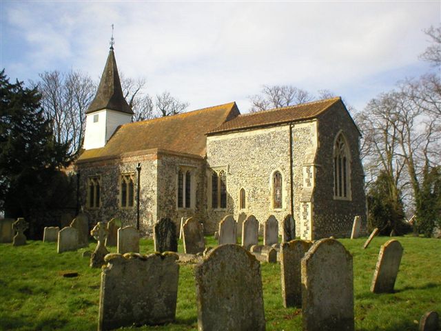
It is situated between East Stourmouth and the Monkton marshes to the north, with the old Red House Ferry to the east and Grove Ferry to the west.  Judith Glover's The Place Names of Kent  (publ. B.T. Batsford Books Ltd., 1976) states:

According to local tradition, the river Stour at this point takes its name from a Mr Pluck, a landlord of the Dog and Duck inn.  During the building of the bridge here last [19th] century, he is said to have ferried the builders to and fro across the river, and in friendly appreciation of his services they nicknamed this stretch of the Stour "Pluck's Gutter".

In June of 2006 I was pleased to be contacted by Mike Holmes, current owner of the Red Ferry House.  He advised:

The name Plucks Gutter is listed from the 1700s and certainly long before the Road Bridge was built in 1902; so the tale that it was named after a Mr Pluck during the bridge building is wrong.  The ferry Cottage was originally built about 1530 when it was a timber framed farmhouse and ferry; it is first recorded as an alehouse as well in 1622 when it was called The Dog and Duck.  Many pubs are called this, especially where dogs were used to flush out ducks to guns and retreive them.

The ferry cottage remained as an alehouse until Francis A. White [owner of the Stourmouth Brewery, and a local councillor] contributed to the building of the new road bridge and the building of a new pub in 1902.  He closed the old Dog and Duck at this time together with the ferry, and the cottage passed eventually to the water board as a sluice keeper's cottage.  I bought it from Southern Water in 1996.

After Henry VIII closed the Augustine monastry in Canterbury, the sea walls of the Wantsum fell into disrepair and the sea started to reclaim the drained land - many of the banks of the Stour are still called to this day "Monk's Wall".  Elizabeth I invited Dutch Protestants [being persecuted by their Spanish Catholic Colonial Masters] to settle in England offering them as much land as they could reclaim from the sea.  A great many took up the offer as can be evidenced by the dutch gables in many East Coast Towns, especially Sandwich and Lincoln.

The traditional way of draining the land was to start with a deep furrow made by a plough and to let the land drain naturally into this - this proved that the drain would flow downhill, difficult to see on what is very flat land; over time this opened out and was widened and deepened by man.  The East Kent word for such a drain is a gutter and the dutch for a plough is ploeg [pronounced plerg rhyming with iceberg].  Plucks Gutter is an corruption and anglisation of these two elements; so the meaning of Plucks Gutter is "ploughed drain".

Maps drawn in the first half of the 19th century sometimes show Plucks Gutter as Plux Gutter.  In 1821-23, the notorious North Kent Gang of smugglers made use of Pluck's Gutter.  They travelled some fourteen miles, on foot, through Trenleypark Wood to Stodmarsh, via Grove Corner to Pluck's Gutter where they crossed the river, northeast to Mount Pleasant then up to Marsh Bay.

I am fortunate to have received an essay from Mrs Maggie Baldwin who was born in Stourmouth; read it, and take a walk through the village in the 1950-1970 timeframe.

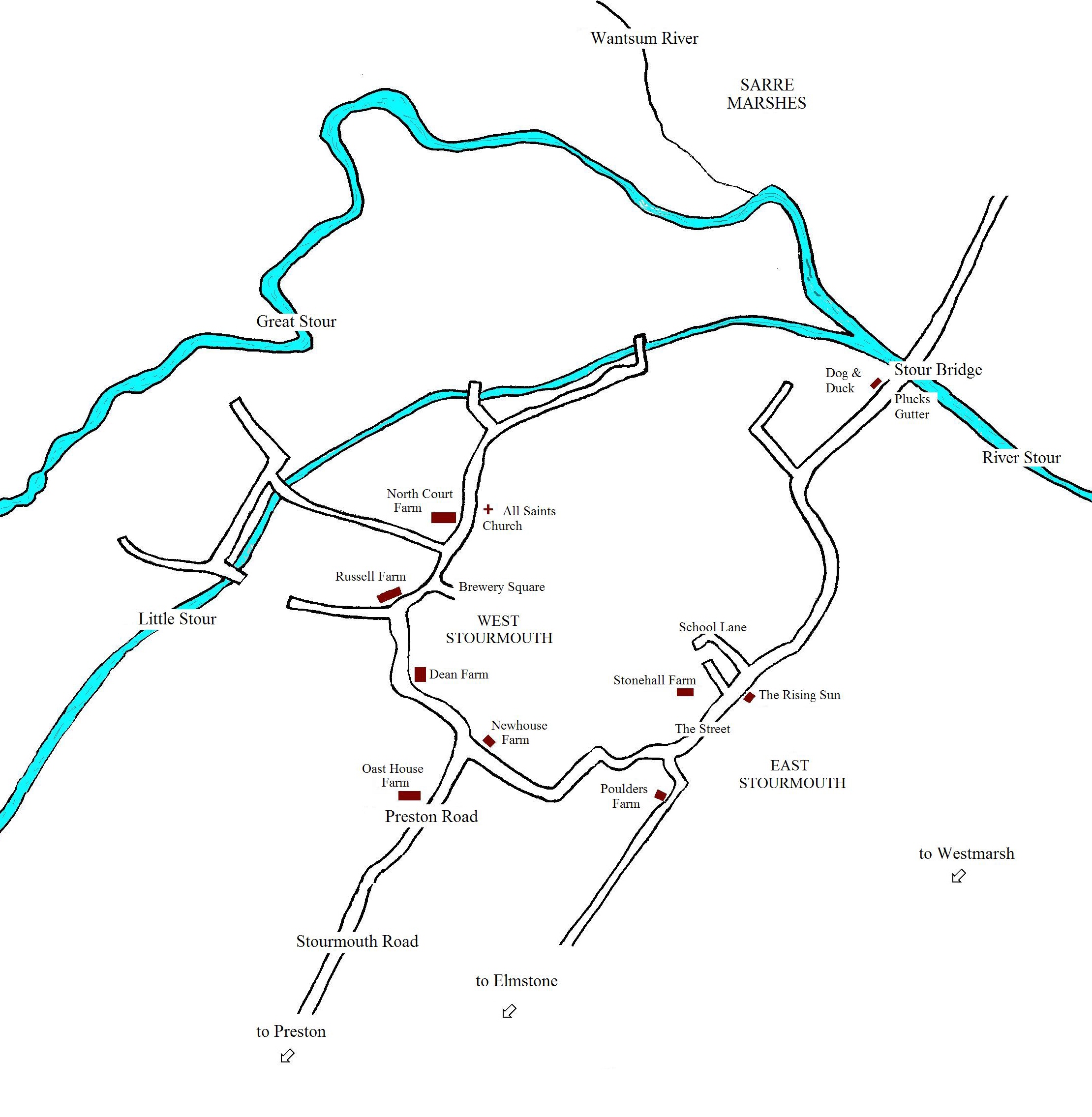
Below is my (very amateur) map of the eastern and western reaches of Stourmouth, as it appears today.


I hope to, eventually, look at various parish chest records that have been filmed by the LDS, such as the Overseers and Churchwardens accounts, and land tax assessments.  I hope they will yield more pertinent information about day to day life in Stourmouth.  The data will, of course, be posted to this website.  Stay tuned! 

Make a free website with Yola